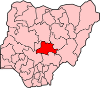
Located in the North-Central geopolitical zone of Nigeria, Nasarawa state has its capital at lafia. The state is bordered by Kaduna, Kogi, Benue, Plateau and Taraba states. Nasarawa state has a total of 13 local government areas which include Akwanga, Doma, Eggon, Karu, Keana, Keffi, Kokona, Lafia, Nasarawa Egon, Nasarawa, Obi, Toto, and Wamba with an estimated total population of 1,863, 278 inhabitants.Ethic groups found in Nasaraw state include the Afo, Agatu, Akye, Alago, Baribari, Bassa, Egbira, Eggon, Fulani , Gade, Gbagyi, Gwandara, Hausa, Jukun, Kanuri, Mada, Ninzom, Arum, Rindei, Yeskwa, Tiv, Arum-tesu, Basa-gumna, Bu, Dibo, Duhwa, Eloyi, Goemai, and Ham. Popular festivals celebrated in Nasarawa state include the Odu, Amiri, Sharo, Omadegye, Awuma dance, Oguh dance, Gbagyi, Gbogum, Oyarere, Ogani fishing, Nzeh Mada, Erehwa, Nasarawa state cultural festival, and the Irewha hunting festivals.
Popular towns in Nasarawa include keffi, Akwanga, Doma and Wamba. Nasarawa state is also home to the Yarin Ruwa falls which is one of the highest waterfalls in Africa. Christianity and Islam are the widely practiced religions in Nasarawa with Hausa and English as the most commonly spoken languages. Tertiary Institutions in Nasarawa state include the Kings Polytechnic Karu, Nasarawa state University Keffi, Bingham University Karu, City College of Education, College of Education Akwanga, Federal Polytechnic Nasarawa, Federal University Lafia, Nasarawa state Polytechnic, and the College of Agriculture Lafia.
Nasarawa state is home to several indigenous dishes which include the very popular Pate delicacy. Important landmarks in Nasarawa state include the Eggon hills, the Farin Ruwa falls, Oku Akpa rock, Numan Rock and Hills, Akiri warm spring, Ara rock, Doma Dam, Hunki ox bow Lake, Keana salt village, Akiri salt village, Crocodile Lake Gizar, Doka-Gide Ria, Tunga Nupawa Lake, Assakio Natural spring water, Ogani fishing water, and the National Gallery of Arts in Lafia.
The Governor of Nasarawa State is Umaru Tanko Al-Makura.
Home of Solid Minerals
Nasarawa boasts a total area of 27,117 km squared with plains and flat lands which are suitable for crop cultivation and animal rearing. The state falls under the Tropical Savannah climate and has two distinct seasons which ae the dry and rainy seasons with average total precipitation estimated at 1100 mm per annum.
The landscape of Nasarawa state is also characterized by the presence of hills, small mountains and elevations. Average humidity in Nasarawa state is estimated at 39 percent.
Nasarawa state has a rich agricultural heritage and is famed for the cultivation of several crops which include cotton, rubber, and yam. Nasarawa state also has substantial amounts of mineral deposits which include salt, cassiterite, clay, columbite, Mica, granite, Limenite, Baryte, Galena, limestone, silica sand, Zinc, Lead, Tale, Gemstone, Chakopyrite, Topaz, Quartz, coal, marble, Iron ore and bauxite.
Trade booms in Nasarawa state with the state playing host to several markets such as the Muhammadu Buhari International market, Karu international market, Mararaba market, Mada station market, Akwanga Central market, and the Tudun wada cattle market
Nasarawa state was created on the 1st of October 1996 after being carved out from Plateau state. the list of past and present governors of Nasarawa state are provided below
Abdullahi Ibrahim- 1996-1998
Bala Mande - 1998-1999
Abdullahi Adamu- 1999-2007
Aliyu Doma- 2007-2011
Umaru Tanko Al-Makura- 2011 to date
4 based on 0 reviews

Find and explore some of the best businesses in Nasarawa State.
© 2025 Manpower Nigeria. All rights reserved.